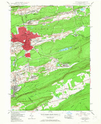
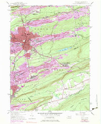
1947 Map of Hazleton
USGS Topo · Published 1967About this map
The anthracite coal heritage of Pennsylvania is etched across this 1947 landscape, where industrial infrastructure meets the steep ridges of Banks Mountain and Spring Mountain. The urban core of Hazleton and West Hazleton stands as a dense grid of streets, anchored by the Post Office and High School. Surrounding the city, numerous smaller patch towns and mining settlements such as Lattimer Mines (PO), Jeanesville, and Beaver Meadows speak to the region's labor history and the dispersed nature of coal extraction during this era.
Find a feature on this map
62 named features on this map. Tap any name to fly to it.
Don’t see what you’re looking for? This feature index may not catch every label — zoom into the map to look around manually.
Map Details
Editions of this 1947 Hazleton Map
5 editions found
Other maps of this area

1889 · Hazleton
USGS Topo · 1:62,500

1891 · Wilkesbarre
USGS Topo · 1:62,500

1891 · Hazleton
USGS Topo · 1:62,500

1892 · Mahanoy
USGS Topo · 1:62,500

1893 · Hazleton
USGS Topo · 1:62,500

1893 · Mahanoy
USGS Topo · 1:62,500

1894 · Shickshinny
USGS Topo · 1:62,500

1894 · Wilkesbarre
USGS Topo · 1:62,500

1943 · Scranton
USGS Topo · 1:125,000

1944 · Newark
USGS Topo · 1:250,000