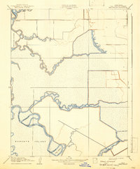
1910 Map of Headreach
USGS Topo · Published 1942About this map
Terminous sits at the northern edge of this labyrinthine waterway network, serving as a primary point of human activity in the heart of the Delta. This landscape is defined by its intricate system of sloughs and reaches that carve through massive low-lying tracts like Roberts Island, Bouldin Island, and Staten Island. The San Joaquin River snakes through the territory, its course modified by man-made improvements such as the Headreach Cutoff and the anchorage at Headreach Landing. The winding paths of Disappointment Slough and White Slough illustrate the complex drainage patterns required to manage these island reclamation projects. Many of these waterways, including Deadman Reach and Fourteenmile Slough, reflect the navigational challenges and specific nomenclature used by early twentieth-century river pilots and farmers before further modern levee developments altered the region.
Find a feature on this map
21 named features on this map. Tap any name to fly to it.
Don’t see what you’re looking for? This feature index may not catch every label — zoom into the map to look around manually.
Map Details
Editions of this 1910 Headreach Map
2 editions found
Other maps of this area

1894 · Lodi
USGS Topo · 1:125,000

1910 · New Hope
USGS Topo · 1:31,680

1910 · Castle
USGS Topo · 1:31,680

1910 · Bouldin
USGS Topo · 1:31,680

1910 · Woodbridge
USGS Topo · 1:31,680

1910 · Headreach
USGS Topo · 1:31,680

1910 · Isleton
USGS Topo · 1:31,680

1913 · Woodward Island
USGS Topo · 1:31,680

1913 · Stockton
USGS Topo · 1:31,680

1913 · Holt
USGS Topo · 1:31,680