
1910 Map of Headreach
USGS Topo · Published 1910About this map
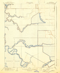
Staten Island, Bouldin Island, and Roberts Island define this 1910 landscape of the California Delta, where reclaimed lands and winding waterways dictated life at the turn of the century. The map illustrates a complex hydraulic network of natural channels and man-made alterations, such as the Headreach Cut-off, designed to improve navigation along the San Joaquin River. Small landings and settlements like Terminous and Headreach Landing serve as critical transfer points for the era's agricultural economy, where riverboats and barges accessed the interior through a maze of sloughs including Potato Slough, White Slough, and Disappointment Slough. This survey captures the region's geography before later 20th-century levee reinforcements and irrigation projects further altered the course of these intricate waterways, providing a precise look at the early river-and-rail connectivity of the Central Valley.
Find a feature on this map
20 named features on this map. Tap any name to fly to it.
Don’t see what you’re looking for? This feature index may not catch every label — zoom into the map to look around manually.
Map Details
Editions of this 1910 Headreach Map
2 editions found
Other maps of this area

1894 · Lodi
USGS Topo · 1:125,000

1910 · New Hope
USGS Topo · 1:31,680

1910 · Castle
USGS Topo · 1:31,680

1910 · Bouldin
USGS Topo · 1:31,680

1910 · Woodbridge
USGS Topo · 1:31,680

1910 · Isleton
USGS Topo · 1:31,680

1913 · Woodward Island
USGS Topo · 1:31,680

1913 · Stockton
USGS Topo · 1:31,680

1913 · Holt
USGS Topo · 1:31,680

1916 · Byron
USGS Topo · 1:62,500