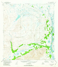
1962 Map of Healy A-2
USGS Topo · Published 1963About this map
Butte Lake sits at the center of an intricate network of alpine waters and glacial drainages in this mid-century survey of the Matanuska-Susitna region. The landscape is defined by the heavy path of the Susitna River and its numerous tributaries, including Gold Creek, Canyon Creek, and Wickersham Creek. The mapping reveals a remote wilderness punctuated by geodetic control points like Vabm Nadiwen and Vabm Win, which served as the literal anchors for the photogrammetric surveys of the 1940s and 1950s. A solitary Gaging Sta near the river bank indicates the importance of water flow monitoring in this unpopulated reach. The presence of the Fairbanks Meridian line running through the eastern portion underscores the massive scale of the land grid system being imposed on this unsurveyed territory.
Find a feature on this map
12 named features on this map. Tap any name to fly to it.
Don’t see what you’re looking for? This feature index may not catch every label — zoom into the map to look around manually.
Map Details
Editions of this 1962 Healy A-2 Map
This is the sole edition of this map. No revisions or reprints were ever made.
Other maps of this area

1949 · Healy B-2
USGS Topo · 1:63,360

1949 · Healy A-1
USGS Topo · 1:63,360

1950 · Talkeetna Mountains
USGS Topo · 1:250,000

1950 · Healy A-3
USGS Topo · 1:63,360

1950 · Healy B-3
USGS Topo · 1:63,360

1950 · Healy B-1
USGS Topo · 1:63,360

1951 · Healy
USGS Topo · 1:250,000

1951 · Talkeetna Mountains D-2
USGS Topo · 1:63,360

1951 · Talkeetna Mountains D-1
USGS Topo · 1:63,360

1951 · Talkeetna Mountains D-3
USGS Topo · 1:63,360