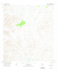
1950 Map of Healy A-3
USGS Topo · Published 1975About this map
Deadman Mountain dominates the central landscape of this 1950s interior Alaskan survey, part of the Alaska Matanuska Susitna Borough. This area, mapped from 1949 aerial photography, reveals a wilderness defined by its intricate drainage systems and glacial landforms before modern infrastructure reached this portion of the Talkeetna Mountains. The map highlights the sprawling course of Deadman Creek as it flows south toward Deadman Lake and Big Lake, while Brushkana Creek carves through the northern reaches. The lack of any roads or trails on this sheet at the time of the 1950 field annotation underscores the region's isolation. Researchers of Alaskan geography will find a pristine record of the high-elevation terrain and swampy lowlands, including the headwaters of Meadow Creek, documented just as the territory was beginning its transition toward statehood.
Find a feature on this map
7 named features on this map. Tap any name to fly to it.
Don’t see what you’re looking for? This feature index may not catch every label — zoom into the map to look around manually.
Map Details
Editions of this 1950 Healy A-3 Map
3 editions found
Other maps of this area

1949 · Healy B-4
USGS Topo · 1:63,360

1949 · Healy B-2
USGS Topo · 1:63,360

1950 · Talkeetna Mountains
USGS Topo · 1:250,000

1950 · Healy A-3
USGS Topo · 1:63,360

1950 · Healy B-3
USGS Topo · 1:63,360

1950 · Healy A-4
USGS Topo · 1:63,360

1951 · Healy
USGS Topo · 1:250,000

1951 · Healy B-4
USGS Topo · 1:63,360

1951 · Talkeetna Mountains D-2
USGS Topo · 1:63,360

1951 · Talkeetna Mountains D-3
USGS Topo · 1:63,360