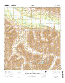
2016 Map of Healy C-3 SE
USGS Topo · Published 2016About this map
Alaska Range peaks dominate this high-altitude landscape in the Healy region of Alaska. The northern portion of the map is defined by the braided path of the Yanert Fork, a wide watercourse characterized by intricate gravel bars and shifting channels common in glacial drainage systems. This glacial outwash plain transitions into steep, high-elevation terrain to the south, where smaller tributaries like Louis Creek and Edgar Creek carve through the mountain slopes. The map provides a precise view of this unpopulated wilderness before any significant human development, highlighting the complex natural drainage patterns and the sheer verticality of the interior mountains.
Find a feature on this map
10 named features on this map. Tap any name to fly to it.
Don’t see what you’re looking for? This feature index may not catch every label — zoom into the map to look around manually.
Map Details
Editions of this 2016 Healy C-3 SE Map
This is the sole edition of this map. No revisions or reprints were ever made.
Other maps of this area

1949 · Healy C-3
USGS Topo · 1:63,360

1949 · Healy B-2
USGS Topo · 1:63,360

1950 · Healy B-3
USGS Topo · 1:63,360

1951 · Healy
USGS Topo · 1:250,000

1951 · Healy C-2
USGS Topo · 1:63,360
1952 · Healy B-3
USGS Topo · 1:63,360
1952 · Healy C-3
USGS Topo · 1:63,360

1952 · Healy B-2
USGS Topo · 1:63,360

1956 · Healy
USGS Topo · 1:250,000
2016 · Healy C-3 NE
USGS Topo · 1:25,000