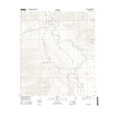
2016 Map of Healy C-4 NW
USGS Topo · Published 2016About this map
The Nenana River carves a deep valley through this portion of Denali National Park, serving as the primary corridor for both the Parks Highway and an extensive network of recreational paths. This 2016 survey documents the infrastructure supporting the park's gateway, including the Mc Kinley National Park Airport and the southern Denali Airport. The terrain transition is sharp, rising from the Triple Lakes area toward the peaks of Mt Fellows and the Mt Healy Trail. Historical transit patterns are visible in the junction of Old Parks @ McKinley Rd, while more recent developments like the Bike Path parallel the main highway. The confluence of the Yanert Fork with the main river highlights the complex hydrology that has shaped this interior Alaskan landscape, connecting isolated water bodies like Horseshoe Lake to the broader regional drainage system.
Find a feature on this map
32 named features on this map. Tap any name to fly to it.
Don’t see what you’re looking for? This feature index may not catch every label — zoom into the map to look around manually.
Map Details
Editions of this 2016 Healy C-4 NW Map
This is the sole edition of this map. No revisions or reprints were ever made.
Other maps of this area

1950 · Healy D-4
USGS Topo · 1:63,360

1950 · Healy C-4
USGS Topo · 1:63,360

1951 · Healy
USGS Topo · 1:250,000

1951 · Healy D-5
USGS Topo · 1:63,360

1952 · Healy D-5
USGS Topo · 1:63,360

1952 · Healy C-5
USGS Topo · 1:63,360
1952 · Healy C-4
USGS Topo · 1:63,360
1952 · Healy D-4
USGS Topo · 1:63,360

1953 · Healy C-5
USGS Topo · 1:63,360

1956 · Healy
USGS Topo · 1:250,000