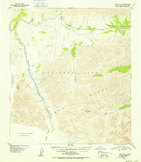
1952 Map of Healy C-5
USGS Topo · Published 1952About this map
Mt Mckinley National Park dominates this mid-century topographic study, capturing the interior wilderness as it was mapped by the U.S. Geological Survey using aerial photography from 1949. The landscape is defined by the high peaks of the Alaska Range, where prominent landmarks like Fang Mtn and Double Mtn rise above deep glacial drainages. Major waterways including the Savage River, Sanctuary River, and Riley Creek carve through the terrain, illustrating the hydrologic network that dictates travel through this subarctic environment. The presence of Refuge Valley and Hines Creek further details the local geography before major modern development. Notably, portions of the western boundary are marked as missing compilation data due to cloud cover during the original 1949 flight, a testament to the practical challenges of mapping the Alaskan interior during this era.
Find a feature on this map
12 named features on this map. Tap any name to fly to it.
Don’t see what you’re looking for? This feature index may not catch every label — zoom into the map to look around manually.
Map Details
Editions of this 1952 Healy C-5 Map
2 editions found

Other maps of this area

1949 · Healy B-4
USGS Topo · 1:63,360

1950 · Healy D-4
USGS Topo · 1:63,360

1950 · Healy C-4
USGS Topo · 1:63,360

1950 · Healy B-5
USGS Topo · 1:63,360

1951 · Healy
USGS Topo · 1:250,000

1951 · Healy B-5
USGS Topo · 1:63,360

1951 · Healy B-4
USGS Topo · 1:63,360

1951 · Healy D-6
USGS Topo · 1:63,360

1951 · Healy D-5
USGS Topo · 1:63,360

1952 · Healy D-5
USGS Topo · 1:63,360