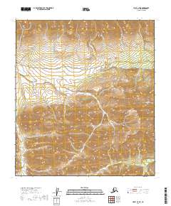
2019 Map of Healy C-5 NE
USGS Topo · Published 2019About this map
Denali National Park encompasses the entirety of this interior Alaskan landscape, characterized by high-elevation drainages and preserved wilderness. The northern reach of the Park Road cuts through the upper portion of the quadrangle, serving as the primary corridor for access and travel through the park interior. Along this route, the Savage Alpine Trail offers a pedestrian path through the steep terrain near the Savage River. The hydrologic pattern is dominated by several significant alpine streams, including Hines Cr, Jenny Cr, and Little Cr, which carve through the townships of T14S R8W and T14S R9W. This 2019 survey documents the modern state of the park's infrastructure and its natural watercourse boundaries before the influence of seasonal fluctuations or environmental changes.
Find a feature on this map
13 named features on this map. Tap any name to fly to it.
Don’t see what you’re looking for? This feature index may not catch every label — zoom into the map to look around manually.
Map Details
Editions of this 2019 Healy C-5 NE Map
This is the sole edition of this map. No revisions or reprints were ever made.
Other maps of this area

1950 · Healy D-4
USGS Topo · 1:63,360

1950 · Healy C-4
USGS Topo · 1:63,360

1951 · Healy
USGS Topo · 1:250,000

1951 · Healy D-5
USGS Topo · 1:63,360

1952 · Healy D-5
USGS Topo · 1:63,360

1952 · Healy C-5
USGS Topo · 1:63,360
1952 · Healy C-4
USGS Topo · 1:63,360
1952 · Healy D-4
USGS Topo · 1:63,360

1953 · Healy C-5
USGS Topo · 1:63,360

1956 · Healy
USGS Topo · 1:250,000