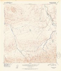
1952 Map of Healy D-5
USGS Topo · Published 1952About this map
Lignite and the nearby Diamond Coal Mine anchor the eastern corridor of this 1952 Alaskan interior survey, where industry and transportation follow the path of the Nenana River. This region illustrates the vital connection between natural resources and the infrastructure required to extract them, centered on the transit provided by The Alaska Railroad and a local Airstrip. To the west, the landscape transitions into the federally protected wilderness of Mt McKinley National Park, defined by the northward flow of the Savage River, Sanctuary River, and Teklanika River. The map documents a frontier environment where remote outposts like Ranger Cabin and various Tractor Trails provide the only human imprint on the northern slopes of the Alaska Range. From the high peaks of Mt Healy to the marshy lowlands of Fish Creek, this record captures the mid-century intersection of conservation and mining.
Find a feature on this map
28 named features on this map. Tap any name to fly to it.
Don’t see what you’re looking for? This feature index may not catch every label — zoom into the map to look around manually.
Map Details
Editions of this 1952 Healy D-5 Map
2 editions found

Other maps of this area

1950 · Fairbanks
USGS Topo · 1:250,000

1950 · Fairbanks A-5
USGS Topo · 1:63,360

1950 · Healy D-4
USGS Topo · 1:63,360

1950 · Healy C-4
USGS Topo · 1:63,360

1950 · Fairbanks A-4
USGS Topo · 1:63,360

1951 · Healy
USGS Topo · 1:250,000

1951 · Fairbanks
USGS Topo · 1:250,000

1951 · Fairbanks A-5
USGS Topo · 1:63,360

1951 · Healy D-6
USGS Topo · 1:63,360

1951 · Healy D-5
USGS Topo · 1:63,360