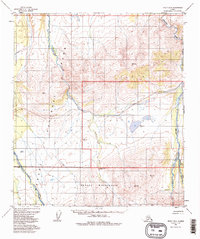
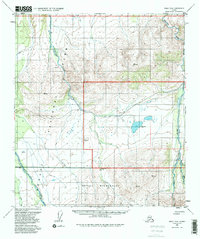
1954 Map of Healy D-6
USGS Topo · Published 1988About this map
Denali National Park and the expansive Denali Wilderness dominate this interior Alaskan landscape as it was documented in the mid-1950s. The terrain is defined by a network of north-flowing glacial meltwater, with the braided channels of the Teklanika River and the Sushana River carving through the center and east, while the East Fork Toklat River anchors the southwestern corner. This survey highlights the minimal human infrastructure present during the era, notably the Ranger Patrol Cabin situated near the riverbanks. Early backcountry access is indicated by trail markers such as Stampede 18 Mi. and Lignite 18 Mi., which provide a sense of the scale and orientation for travelers moving through these remote reaches before the modern era of park management. Several geodetic markers, including VABM 3521 Teka and VABM 1906 Lake, serve as critical points for understanding the early mapping of this subarctic wilderness.
Find a feature on this map
15 named features on this map. Tap any name to fly to it.
Don’t see what you’re looking for? This feature index may not catch every label — zoom into the map to look around manually.
Map Details
Editions of this 1954 Healy D-6 Map
5 editions found
Other maps of this area

1948 · Kantishna River
USGS Topo · 1:250,000

1950 · Fairbanks
USGS Topo · 1:250,000

1950 · Fairbanks A-5
USGS Topo · 1:63,360

1951 · Healy
USGS Topo · 1:250,000

1951 · Kantishna River
USGS Topo · 1:250,000

1951 · Fairbanks
USGS Topo · 1:250,000

1951 · Fairbanks A-5
USGS Topo · 1:63,360

1951 · Mount McKinley D-1
USGS Topo · 1:63,360

1951 · Healy D-6
USGS Topo · 1:63,360

1951 · Healy D-5
USGS Topo · 1:63,360