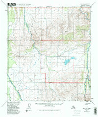
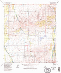
1954 Map of Healy D-6
USGS Topo · Published 1988About this map
Denali National Park and the expansive Denali Wilderness dominate this interior Alaskan landscape, surveyed in the mid-1950s. The terrain is defined by a network of parallel watercourses flowing northward, most notably the Sushana River and the braided channels of the Teklanika River and East Fork Toklat River. Evidence of early park administration and wilderness management is visible in the placement of the Ranger Patrol Cabin, situated near the confluence of local tributaries. The map captures the region before significant modern development, documenting the raw hydrology of the Sanctuary River and the intricate glacial drainage patterns that shaped this section of the Alaska Range foothills.
Find a feature on this map
13 named features on this map. Tap any name to fly to it.
Don’t see what you’re looking for? This feature index may not catch every label — zoom into the map to look around manually.
Map Details
Editions of this 1954 Healy D-6 Map
5 editions found
Other maps of this area

1948 · Kantishna River
USGS Topo · 1:250,000

1950 · Fairbanks
USGS Topo · 1:250,000

1950 · Fairbanks A-5
USGS Topo · 1:63,360

1951 · Healy
USGS Topo · 1:250,000

1951 · Kantishna River
USGS Topo · 1:250,000

1951 · Fairbanks
USGS Topo · 1:250,000

1951 · Fairbanks A-5
USGS Topo · 1:63,360

1951 · Mount McKinley D-1
USGS Topo · 1:63,360

1951 · Healy D-6
USGS Topo · 1:63,360

1951 · Healy D-5
USGS Topo · 1:63,360