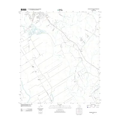
2013 Map of Hearne South
USGS Topo · Published 2013About this map
Hearne serves as the focal point of this South Texas landscape, where the town’s grid meets a network of country roads and rail corridors. The area’s aviation history is visible through the Hearne Municipal Airport and Corpora Airport, while its local heritage is anchored by sites like Saint Luke Cem, Hearne Cem, and Galloway Cem. Moving south from the town center, the terrain transitions into agricultural land and small settlements such as Sutton, Nicholas, and the community of Tatsie near the Tatsie Crossing. The hydrology is dominated by the meandering Brazos River at the southwestern edge, fed by a series of creeks including Pin Oak Cr, Lost Cr, and Spring Cr. This survey captures the rural character of Robertson County, where long-established family names appear on landmarks like McCarver Ln and Bowman Rd.
Find a feature on this map
63 named features on this map. Tap any name to fly to it.
Don’t see what you’re looking for? This feature index may not catch every label — zoom into the map to look around manually.
Map Details
Editions of this 2013 Hearne South Map
This is the sole edition of this map. No revisions or reprints were ever made.
Other maps of this area

1954 · Austin
USGS Topo · 1:250,000

1956 · Bryan
USGS Topo · 1:62,500

1956 · Caldwell
USGS Topo · 1:62,500

1961 · Mumford
USGS Topo · 1:24,000

1961 · Hearne North
USGS Topo · 1:24,000

1961 · Hearne South
USGS Topo · 1:24,000

1962 · Goodwill
USGS Topo · 1:24,000

1962 · Calvert
USGS Topo · 1:24,000

1962 · Wheelock
USGS Topo · 1:24,000
1962 · Gause
USGS Topo · 1:24,000