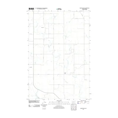
2011 Map of Heart Butte
USGS Topo · Published 2011About this map
Heart Butte Creek and its many winding tributaries define the drainage of this prairie landscape in Morton County. The terrain is characterized by isolated high points such as Wolf Butte in the north and the namesake Heart Butte to the west, which rise above a network of section-line roads and rural corridors like Farmer's Trl. A sense of local heritage is centered at the Old Saint Joseph Cemetery, situated near the banks of Lindstrom Creek. This 2011 survey reflects the enduring agricultural character of the region, where a rectilinear grid of local roads like 66th Ave SW and 52nd St SW organizes the wide-open geography between these prominent buttes and the creek bottoms.
Find a feature on this map
26 named features on this map. Tap any name to fly to it.
Don’t see what you’re looking for? This feature index may not catch every label — zoom into the map to look around manually.
Map Details
Editions of this 2011 Heart Butte Map
This is the sole edition of this map. No revisions or reprints were ever made.
Other maps of this area

1938 · Heart Butte
USGS Topo · 1:48,000

1944 · Heart Butte
USGS Topo · 1:62,500

1954 · Bismarck
USGS Topo · 1:250,000

1958 · Bismarck
USGS Topo · 1:250,000

1960 · Dengate
USGS Topo · 1:24,000

1960 · Glen Ullin
USGS Topo · 1:24,000

1960 · Heart Butte NW
USGS Topo · 1:24,000

1960 · Heart Butte
USGS Topo · 1:24,000
1970 · Glen Ullin SW
USGS Topo · 1:24,000

1980 · Crown Butte Creek NW
USGS Topo · 1:24,000