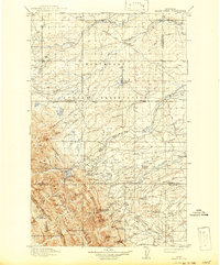
1918 Map of Heart Butte
USGS Topo · Published 1942About this map
The Blackfeet Indian Reservation dominates the northern half of this landscape, where the prairie begins its dramatic ascent into the Continental Divide. Surveyed between 1907 and 1914, the map documents a transition from the plains settlements of Family and Piegan to the high peaks of the Lewis and Clark National Forest. Water management is a central theme of the era, seen in the presence of the Birch Creek Dam and Swift Reservoir, which capture runoff from the mountains to support the ranching and farming communities below. Educational life on the frontier is preserved through the locations of rural schoolhouses such as Fish Lake School, Terry School, and Jensen School. To the west, the topography turns vertical at Feather Woman Mtn and Mt Patrick Gass, marking the boundary of the rugged Sawtooth Ridge.
Find a feature on this map
93 named features on this map. Tap any name to fly to it.
Don’t see what you’re looking for? This feature index may not catch every label — zoom into the map to look around manually.
Map Details
Editions of this 1918 Heart Butte Map
3 editions found
Other maps of this area

1901 · Browning
USGS Topo · 1:125,000

1903 · Browning
USGS Topo · 1:125,000

1903 · Saypo
USGS Topo · 1:125,000

1907 · Blackfoot Res.
USGS Topo · 1:48,000

1909 · Cut Bank
USGS Topo · 1:125,000

1911 · Blackfoot
USGS Topo · 1:125,000

1912 · Cut Bank
USGS Topo · 1:125,000

1913 · Marias Pass
USGS Topo · 1:125,000

1914 · Heart Butte
USGS Topo · 1:125,000

1918 · Heart Butte
USGS Topo · 1:125,000