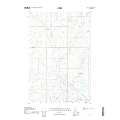
2019 Map of Heart Lake
USGS Topo · Published 2019About this map
Heart Lake and its surrounding wetlands anchor this Clearwater County landscape, which is defined by an intricate network of glacial lakes and low-lying sloughs. The presence of both the Railroad Grade Trl and the Mallard Grade Trl indicates a historical reliance on heavy transport corridors for timber or transit across the watery terrain. These straight-line paths cut through the irregular shorelines of Mud Lake, Tamarack Lake, and Mallard Lake, providing a clear record of how industry shaped movement through the North Woods. Near the southern edge of the survey, the Stevens Cem sits just off Anchor Matson Rd, offering a specific point of interest for genealogists tracking early local families. The map also documents the drainage of the area via Hier Cr and Sucker Cr, connecting smaller bodies like Carver Lake and Klepps Slough into the broader regional watershed.
Find a feature on this map
43 named features on this map. Tap any name to fly to it.
Don’t see what you’re looking for? This feature index may not catch every label — zoom into the map to look around manually.
Map Details
Editions of this 2019 Heart Lake Map
This is the sole edition of this map. No revisions or reprints were ever made.
Other maps of this area

1954 · Bemidji
USGS Topo · 1:250,000

1957 · Bemidji
USGS Topo · 1:250,000

1958 · Bemidji
USGS Topo · 1:250,000

1969 · Anchor Hill
USGS Topo · 1:24,000

1969 · Long Lost Lake
USGS Topo · 1:24,000
1969 · Zerkel
USGS Topo · 1:24,000

1969 · Heart Lake
USGS Topo · 1:24,000
1969 · Zerkel NW
USGS Topo · 1:24,000
1969 · Upper Rice Lake
USGS Topo · 1:24,000

1972 · Alida
USGS Topo · 1:24,000