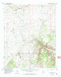
1954 Map of Heaton Knolls
USGS Topo · Published 1983About this map
Red Blanket Ranch and the Findlay Knolls anchor the southern reaches of this 1950s survey, a landscape defined by an extensive network of water catchments and livestock reservoirs. The topography reveals a complex system of plateaus and drainages, including the broad Yellowstone Mesa and the deep incisions of Hacks Canyon. Notable water features such as Caanon Reservoir, Wild Band Reservoir, and Sims Reservoir are scattered across the high desert, indicating the intensive range management of the era. To the south, the terrain rises toward the northern slopes of Mount Trumbull, while the northern portion is dominated by the Upper Clay Hole Valley. The presence of the CCC Trail Reservoir points to the legacy of public works projects in this portion of Mohave County. A singular Trench notation suggests localized mineral exploration or industrial activity amidst the vast canyonlands.
Find a feature on this map
40 named features on this map. Tap any name to fly to it.
Don’t see what you’re looking for? This feature index may not catch every label — zoom into the map to look around manually.
Map Details
Editions of this 1954 Heaton Knolls Map
3 editions found

Other maps of this area

1886 · Mt. Trumbull
USGS Topo · 1:250,000

1886 · Kaibab
USGS Topo · 1:250,000

1892 · Mt. Trumbull
USGS Topo · 1:250,000

1953 · Grand Canyon
USGS Topo · 1:250,000

1954 · Heaton Knolls NW
USGS Topo · 1:24,000

1954 · Lost Spring SE
USGS Topo · 1:24,000
1954 · Short Creek SW
USGS Topo · 1:24,000

1954 · Short Creek SE
USGS Topo · 1:24,000

1954 · Heaton Knolls SE
USGS Topo · 1:24,000

1954 · Fredonia SW
USGS Topo · 1:24,000