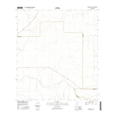
2016 Map of Hebbronville SE
USGS Topo · Published 2016About this map
Palo Blanco Cr and Laborcitas Cr meander through this section of the South Texas brush country, where Jim Hogg, Duval, and Brooks counties meet. The landscape is defined by the ephemeral drainage patterns typical of the region, where seasonal creeks carve subtle variations into the terrain. A sparse network of county roads and ranch access routes, including La Florida Ranch Rd and Los Calzones Rd, provides the primary infrastructure for the area's large-scale ranching operations. The boundary lines between Duval and Jim Hogg counties and Brooks and Jim Hogg counties are prominently marked, reflecting the importance of historical land divisions in this rural territory. This map serves as a clear record of the intersection of these three counties and the ranching lanes that connect them in the mid-2010s.
Find a feature on this map
14 named features on this map. Tap any name to fly to it.
Don’t see what you’re looking for? This feature index may not catch every label — zoom into the map to look around manually.
Map Details
Editions of this 2016 Hebbronville SE Map
This is the sole edition of this map. No revisions or reprints were ever made.
Other maps of this area

1921 · Falfurrias
USGS Topo · 1:125,000

1956 · Laredo
USGS Topo · 1:250,000

1967 · Hebbronville SE
USGS Topo · 1:24,000

1967 · Realitos
USGS Topo · 1:24,000

1967 · Hebbronville NW
USGS Topo · 1:24,000

1967 · Hebbronville
USGS Topo · 1:24,000

1968 · Palomas Ranch NW
USGS Topo · 1:24,000

1968 · Concepcion NW
USGS Topo · 1:24,000
1969 · Ramirez
USGS Topo · 1:24,000
1972 · Baluarte Ranch
USGS Topo · 1:24,000