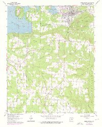
1963 Map of Heber Springs
USGS Topo · Published 1976About this map
Heber Springs sits at the northern edge of this survey, bordered by the rising waters of Greers Ferry Lake and the rugged topography of Round Mountain. The map illustrates a transitional period for Cleburne County, showing the extensive shoreline of the lake at its normal pool elevation of 461 feet alongside remnants of earlier industrial infrastructure like the Sulphur Railroad. Rural life is anchored by numerous country churches and burial grounds, including Mt Olive Ch, Friendship Ch, and the Palestine Cem.
Find a feature on this map
55 named features on this map. Tap any name to fly to it.
Don’t see what you’re looking for? This feature index may not catch every label — zoom into the map to look around manually.
Map Details
Editions of this 1963 Heber Springs Map
3 editions found
Other maps of this area

1890 · Batesville
USGS Topo · 1:125,000

1891 · Batesville
USGS Topo · 1:125,000

1892 · Mountain View
USGS Topo · 1:125,000

1894 · Mountain View
USGS Topo · 1:125,000

1953 · Memphis
USGS Topo · 1:250,000

1956 · Memphis
USGS Topo · 1:250,000

1956 · Russellville
USGS Topo · 1:250,000

1963 · Rose Bud
USGS Topo · 1:24,000

1963 · Quitman
USGS Topo · 1:24,000

1963 · West Pangburn
USGS Topo · 1:24,000