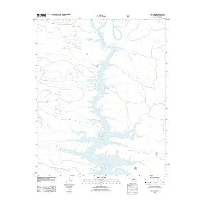
2013 Map of Hee Creek
USGS Topo · Published 2013About this map
Broken Bow Lake dominates this portion of McCurtain County, where the impounded waters of the Mountain Fork fill deep winding valleys. This 2013 survey reveals the complex shoreline created by the flooding of numerous tributaries, including Hudson Creek and Buck Creek. The surrounding terrain is defined by significant ridges such as Hee Mountain and Holly Mountain, which survived the inundation to overlook the modern reservoir. The map documents a wilderness landscape managed by the U.S. Forest Service, crisscrossed by specialized access roads like d1853 and 54160. Beyond the lake, the topography remains a network of creek drainages, from Boktuklo Creek in the north to the diverging branches of North Holly Creek and South Holly Creek further south. The map provides an essential record of the local hydrology and forest road infrastructure in the early 21st century.
Find a feature on this map
35 named features on this map. Tap any name to fly to it.
Don’t see what you’re looking for? This feature index may not catch every label — zoom into the map to look around manually.
Map Details
Editions of this 2013 Hee Creek Map
This is the sole edition of this map. No revisions or reprints were ever made.
Other maps of this area

1902 · Lukfata
USGS Topo · 1:125,000

1950 · Mcalester
USGS Topo · 1:250,000

1959 · Golden
USGS Topo · 1:62,500

1959 · Broken Bow
USGS Topo · 1:62,500

1960 · Bethel
USGS Topo · 1:62,500

1960 · Smithville
USGS Topo · 1:62,500

1962 · McAlester
USGS Topo · 1:250,000

1965 · McAlester
USGS Topo · 1:250,000
1976 · Broken bow NE
USGS Topo · 1:24,000
1981 · Smithville
USGS Topo · 1:24,000