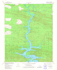
1981 Map of Hee Creek
USGS Topo · Published 1981About this map
Mountain Fork dominates this portion of the Ouachita Mountains, flowing south into the expansive waters of Broken Bow Lake. The landscape is characterized by its high relief and dense hydrological network, with the reservoir's fingers reaching deep into valleys formed by South Holly Creek and Cane Creek. The eastern portion of the map is preserved within the Mc Curtain County State Wilderness Area, where North Linson Creek and South Linson Creek drain from the slopes of White Oak Mountain. A clear infrastructure for forest management and recreation is visible through the presence of a Boat Ramp on the lake and the Lookout Tower Hee atop the heights of Hee Mountain. This 1981 survey documents the impact of the reservoir on the regional topography and the continued importance of the wilderness area for conservation.
Find a feature on this map
31 named features on this map. Tap any name to fly to it.
Don’t see what you’re looking for? This feature index may not catch every label — zoom into the map to look around manually.
Map Details
Editions of this 1981 Hee Creek Map
This is the sole edition of this map. No revisions or reprints were ever made.
Other maps of this area

1902 · Lukfata
USGS Topo · 1:125,000

1950 · Mcalester
USGS Topo · 1:250,000

1959 · Golden
USGS Topo · 1:62,500

1959 · Broken Bow
USGS Topo · 1:62,500

1960 · Bethel
USGS Topo · 1:62,500

1960 · Smithville
USGS Topo · 1:62,500

1962 · McAlester
USGS Topo · 1:250,000

1965 · McAlester
USGS Topo · 1:250,000
1976 · Broken bow NE
USGS Topo · 1:24,000
1981 · Smithville
USGS Topo · 1:24,000