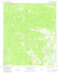
1980 Map of Heiberger
USGS Topo · Published 1980About this map
Heiberger and the winding Cahaba River anchor this 1980 survey of the borderlands between Perry and Bibb Counties. The landscape is dominated by the dense woodlands of the Talladega National Forest, with Cave Mountain rising above the northern creeks. Local history is deeply etched into the topography through a network of rural congregations and family burial grounds, including Sardis Ch, Mt Nebo Ch, and the Bethesda Cem.
Find a feature on this map
25 named features on this map. Tap any name to fly to it.
Don’t see what you’re looking for? This feature index may not catch every label — zoom into the map to look around manually.
Map Details
Editions of this 1980 Heiberger Map
2 editions found
Other maps of this area

1953 · Montgomery
USGS Topo · 1:250,000

1956 · Montgomery
USGS Topo · 1:250,000

1957 · Montgomery
USGS Topo · 1:250,000

1959 · Summerfield
USGS Topo · 1:62,500

1979 · Marion North
USGS Topo · 1:24,000

1979 · Morgan Springs
USGS Topo · 1:24,000

1979 · Harrisburg
USGS Topo · 1:24,000

1979 · Pondville
USGS Topo · 1:24,000

1980 · Payne Lake
USGS Topo · 1:24,000
1980 · Centreville West
USGS Topo · 1:24,000