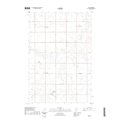
2018 Map of Heil
USGS Topo · Published 2018About this map
The small settlement of Heil serves as the focal point for this section of Grant County, situated within the Township and Range grid system. This rural landscape is defined by the winding course of Antelope Cr, which meanders through the central and northern portions of the map. Local history is anchored near the townsite by the presence of both Prairie View Cem and Peace Cem, providing vital reference points for genealogists and researchers of the area's early families. To the west, the prominent rise of Elm Butte stands above the surrounding plains, punctuating a topography otherwise dominated by a regular network of section-line roads, such as 64th St SW and 71st St SW. The arrangement of these features illustrates the enduring agricultural character of the North Dakota prairie into the twenty-first century.
Find a feature on this map
17 named features on this map. Tap any name to fly to it.
Don’t see what you’re looking for? This feature index may not catch every label — zoom into the map to look around manually.
Map Details
Editions of this 2018 Heil Map
This is the sole edition of this map. No revisions or reprints were ever made.
Other maps of this area

1938 · Heart Butte
USGS Topo · 1:48,000

1944 · Heart Butte
USGS Topo · 1:62,500

1954 · Bismarck
USGS Topo · 1:250,000

1958 · Bismarck
USGS Topo · 1:250,000

1972 · Carson SE
USGS Topo · 1:24,000

1972 · Leith
USGS Topo · 1:24,000

1972 · Sheep Creek Dam
USGS Topo · 1:24,000
1980 · Lake Tschida East
USGS Topo · 1:24,000

1980 · Crown Butte Creek SE
USGS Topo · 1:24,000

1980 · Heil
USGS Topo · 1:24,000