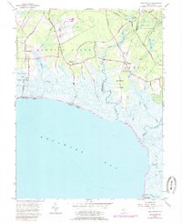
1957 Map of Heislerville
USGS Topo · Published 1984About this map
Delaware Bay defines the southern reach of this coastal survey, where the marshes of Cumberland and Cape May Counties meet the tide. Along the upper margin, the State Prison Farm and Belleplain State Forest occupy significant acreage, contrasting with the scattered residential clusters at Heislerville, Leesburg, and Delmont. This landscape is heavily shaped by its hydrology, with an intricate network of waterways such as West Creek, East Creek, and the winding Dennis Creek feeding into the bay.
Find a feature on this map
49 named features on this map. Tap any name to fly to it.
Don’t see what you’re looking for? This feature index may not catch every label — zoom into the map to look around manually.
Map Details
Editions of this 1957 Heislerville Map
4 editions found
Other maps of this area

1888 · Dennisville
USGS Topo · 1:62,500

1890 · Tuckahoe
USGS Topo · 1:62,500

1890 · Maurice Cove
USGS Topo · 1:62,500

1890 · Bridgeton
USGS Topo · 1:62,500

1891 · Maurice Cove
USGS Topo · 1:62,500

1893 · Tuckahoe
USGS Topo · 1:62,500

1894 · Dennisville
USGS Topo · 1:62,500

1894 · Bridgeton
USGS Topo · 1:62,500

1899 · Vineland
USGS Topo · 1:125,000

1918 · Tuckahoe
USGS Topo · 1:62,500
Featured Places
- Middle Township, NJ
- Maurice River Township, NJ
- Dennis Township, NJ
- Delmont, Maurice River Township
- Heislerville, Maurice River Township