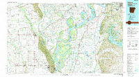
1990 Map of Helena
USGS Topo · Published 1991About this map
Crowleys Ridge rises as a prominent geologic feature amidst the delta lowlands, anchoring the western side of the Mississippi River valley. This 1990 survey captures a complex riverine landscape defined by shifting channels and backwater bayous, including Whiskey Island and Hardin Point. The settlement pattern reflects the area's agricultural and transportation history, with rail lines like the Missouri Pacific RR and St Louis Southwestern RR connecting towns such as Marianna, Forrest City, and the river port of Helena. To the east, the Coldwater River and Arkabutla State Wildlife Refuge dominate the Mississippi side of the map. Between the river's winding oxbows like Horseshoe Lake and the protected woodlands of the St Francis National Forest, the map reveals a region carefully managed for both commerce and conservation in the late twentieth century.
Find a feature on this map
183 named features on this map. Tap any name to fly to it.
Don’t see what you’re looking for? This feature index may not catch every label — zoom into the map to look around manually.
Map Details
Editions of this 1990 Helena Map
This is the sole edition of this map. No revisions or reprints were ever made.
Other maps of this area

1908 · Lula
USGS Topo · 1:24,000

1908 · Dundee
USGS Topo · 1:24,000

1908 · Hollywood
USGS Topo · 1:24,000

1908 · Moon Lake
USGS Topo · 1:24,000

1908 · Walnut Lake
USGS Topo · 1:24,000

1908 · Lake Cormorant
USGS Topo · 1:24,000

1910 · Dundee
USGS Topo · 1:31,680

1910 · Walnut Lake
USGS Topo · 1:31,680

1912 · Lake Cormorant
USGS Topo · 1:31,680

1912 · Moon Lake
USGS Topo · 1:31,680