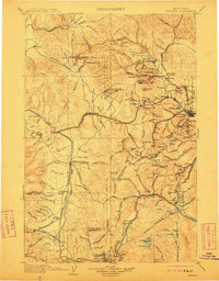
1903 Map of Helena
USGS Topo · Published 1911About this map
The Continental Divide winds through this late 19th-century survey, anchoring a region defined by intense mineral extraction and the rapid expansion of rail infrastructure. Helena serves as the focal point, surrounded by industrial activity in the Scratchgravel Hills and at Ft. Harrison. To the west and south, the landscape is dotted with mining operations and camps such as Marysville, Wickes, and Rimini, while the presence of the Pioneer and Yam Hill mills signifies the era's technological reach into the mountains.
Find a feature on this map
159 named features on this map. Tap any name to fly to it.
Don’t see what you’re looking for? This feature index may not catch every label — zoom into the map to look around manually.
Map Details
Editions of this 1903 Helena Map
4 editions found

Other maps of this area

1886 · Great Falls
USGS Topo · 1:250,000

1886 · Fort Logan
USGS Topo · 1:250,000

1888 · Three Forks
USGS Topo · 1:250,000

1889 · Helena
USGS Topo · 1:250,000

1893 · Helena
USGS Topo · 1:250,000

1893 · Dillon
USGS Topo · 1:250,000

1894 · Three Forks
USGS Topo · 1:250,000

1895 · Three Forks
USGS Topo · 1:250,000

1899 · Boulder
USGS Topo · 1:125,000

1899 · Helena
USGS Topo · 1:62,500