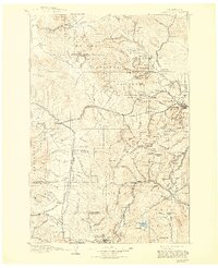
1903 Map of Helena
USGS Topo · Published 1943About this map
The Continental Divide winds through this turn-of-the-century landscape, separating the mining districts of the Helena National Forest from the emerging industrial hubs of the southwest. Surveyed between 1888 and 1899, the map reveals the complex rail network of the Northern Pacific RR and Great Northern RR as they navigate the high passes of the Garnet Range. Large-scale mining operations are evident at Butte and Walkerville, while smaller camps like Marysville, Rimini, and Wickes dot the gulches and peaks.
Find a feature on this map
185 named features on this map. Tap any name to fly to it.
Don’t see what you’re looking for? This feature index may not catch every label — zoom into the map to look around manually.
Map Details
Editions of this 1903 Helena Map
4 editions found

Other maps of this area

1886 · Great Falls
USGS Topo · 1:250,000

1886 · Fort Logan
USGS Topo · 1:250,000

1888 · Three Forks
USGS Topo · 1:250,000

1889 · Helena
USGS Topo · 1:250,000

1893 · Helena
USGS Topo · 1:250,000

1893 · Dillon
USGS Topo · 1:250,000

1894 · Three Forks
USGS Topo · 1:250,000

1895 · Three Forks
USGS Topo · 1:250,000

1899 · Boulder
USGS Topo · 1:125,000

1899 · Helena
USGS Topo · 1:62,500