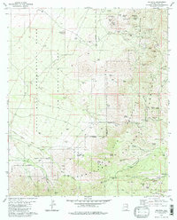
1981 Map of Helvetia
USGS Topo · Published 1985About this map
Mining operations and cattle ranching dominate this corner of the Santa Rita Mountains, where the 1981 landscape is defined by its deep canyons and legacy of extraction. The former community of Helvetia is noted here as a site, accompanied by the nearby Helvetia Cem, serving as a silent reminder of the area's copper mining boom. The eastern slopes are riddled with historical claims including the Narragansett Mine, Omega Mine, and Copper Duke Mine, while the southern reaches towards Greaterville show the transition from the high peaks to the gulches of the Santa Ritas.
Find a feature on this map
71 named features on this map. Tap any name to fly to it.
Don’t see what you’re looking for? This feature index may not catch every label — zoom into the map to look around manually.
Map Details
Editions of this 1981 Helvetia Map
2 editions found
Other maps of this area

1904 · Patagonia
USGS Topo · 1:125,000

1905 · Patagonia
USGS Topo · 1:125,000

1922 · Agus Caliente
USGS Topo · 1:62,500

1926 · Helvetia
USGS Topo · 1:62,500

1932 · Elgin
USGS Topo · 1:62,500

1940 · Elgin
USGS Topo · 1:62,500

1947 · Elgin
USGS Topo · 1:62,500

1948 · Sonoita
USGS Topo · 1:24,000

1956 · Nogales
USGS Topo · 1:250,000

1958 · Nogales
USGS Topo · 1:250,000