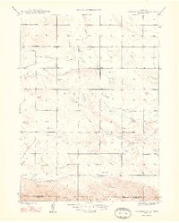
1948 Map of Hemingford 4 SE
USGS Topo · Published 1948About this map
Snake Creek and Point Rocks Creek wind through this mid-century landscape of the High Plains, where the drainage patterns of the Wright township reflect a reliance on intermittent water sources and groundwater management. The survey captures a sparsely populated ranching or farming region defined by a systematic grid of section lines and early infrastructure. Local civic life is anchored by several rural landmarks, including School No 9 and School No 16, which served the scattered families of the district. The presence of the Hagaman Cem provides a specific point of interest for genealogists tracing early residents in this part of western Nebraska. Numerous windmills are mapped across the terrain, emphasizing the critical role of pumped water for livestock and homesteads in the arid climate near the border of Box Butte and Morrill counties.
Find a feature on this map
12 named features on this map. Tap any name to fly to it.
Don’t see what you’re looking for? This feature index may not catch every label — zoom into the map to look around manually.
Map Details
Editions of this 1948 Hemingford 4 SE Map
3 editions found
Other maps of this area

1896 · Browns Creek
USGS Topo · 1:125,000

1898 · Camp Clarke
USGS Topo · 1:125,000

1899 · Browns Creek
USGS Topo · 1:125,000

1947 · Bronco Lake
USGS Topo · 1:24,000

1948 · Hemingford 4 SW
USGS Topo · 1:24,000

1948 · Hemingford 4 SE
USGS Topo · 1:24,000

1948 · Berea Creek West
USGS Topo · 1:24,000

1948 · Hemingford 4 NE
USGS Topo · 1:24,000

1948 · Hemingford 4 NW
USGS Topo · 1:24,000

1949 · Lynn
USGS Topo · 1:62,500