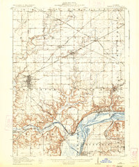
1911 Map of Hennepin
USGS Topo · Published 1933About this map
Princeton serves as the primary hub of this landscape, its structured street grid standing in contrast to the winding wetlands and bluffs along the Illinois River. The map reveals a complex rail-and-water industrial network, where the Chicago Rock Island and Pacific and other lines intersect to serve riverfront settlements. Near Depue, the presence of Depue Lake and Spring Lake indicates a rich alluvial environment, while the interior is dotted with local social centers like the Berean Church and Highland School.
Find a feature on this map
50 named features on this map. Tap any name to fly to it.
Don’t see what you’re looking for? This feature index may not catch every label — zoom into the map to look around manually.
Map Details
Editions of this 1911 Hennepin Map
2 editions found
Other maps of this area

1893 · Lacon
USGS Topo · 1:62,500

1893 · Hennepin
USGS Topo · 1:62,500

1893 · Lasalle
USGS Topo · 1:62,500

1909 · Hennepin
USGS Topo · 1:62,500

1911 · La Salle
USGS Topo · 1:62,500

1911 · Hennepin
USGS Topo · 1:62,500

1913 · La Salle
USGS Topo · 1:62,500

1921 · Buda
USGS Topo · 1:62,500

1923 · Buda
USGS Topo · 1:62,500

1933 · Lacon
USGS Topo · 1:62,500