
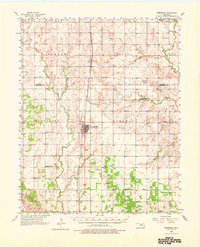
1956 Map of Hennessey
USGS Topo · Published 1957About this map
Hennessey serves as the central hub for this portion of the Oklahoma prairie in the mid-1950s, bisected by the Chicago Rock Island and Pacific railroad line. The surrounding countryside is defined by a dense network of rural infrastructure, including a variety of community focal points like the Oakview Community Hall and numerous country churches such as Maple Grove Ch and Union Chapel. The transition of the local landscape is evident at the Lyon Valley Sch (Abandoned), which marks the evolution of rural education in Kingfisher County.
Find a feature on this map
41 named features on this map. Tap any name to fly to it.
Don’t see what you’re looking for? This feature index may not catch every label — zoom into the map to look around manually.
Map Details
Editions of this 1956 Hennessey Map
2 editions found
Other maps of this area

1892 · Kingfisher
USGS Topo · 1:125,000

1893 · Lovell
USGS Topo · 1:62,500

1893 · Hennessey
USGS Topo · 1:62,500

1893 · Loyal
USGS Topo · 1:62,500

1893 · Ames
USGS Topo · 1:62,500

1895 · Kingfisher
USGS Topo · 1:125,000

1954 · Oklahoma City
USGS Topo · 1:250,000

1955 · Clinton
USGS Topo · 1:250,000

1955 · Enid
USGS Topo · 1:250,000

1955 · Woodward
USGS Topo · 1:250,000