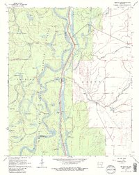
1967 Map of Henrico NE
USGS Topo · Published 1984About this map
The White River National Wildlife Refuge dominates this landscape, preserving a complex system of bottomland hardwoods and oxbow lakes along the meandering White River. The boundary between Phillips and Arkansas counties follows the river's winding path, illustrating how political borders were often tied to shifting watercourses. Numerous named lakes such as Horseshoe Lake, Star Lake, and Bear Lake indicate former river channels, while features like Jackass Point and Wamac Point mark the sharp bends of the contemporary waterway. Evidence of human adaptation to the floodplain is visible at Hudsons Landing and a Pumping Station near Little Island, where levees and managed drainage allow for agricultural activity in the eastern sections of the quadrangle. The intricate network of smaller tributaries, including Essex Bayou and Prairie Bayou, highlights the seasonal rhythm of the Delta's wetlands in the mid-1960s.
Find a feature on this map
48 named features on this map. Tap any name to fly to it.
Don’t see what you’re looking for? This feature index may not catch every label — zoom into the map to look around manually.
Map Details
Editions of this 1967 Henrico NE Map
3 editions found
Other maps of this area

1930 · Mellwood
USGS Topo · 1:62,500

1939 · Modoc
USGS Topo · 1:62,500

1939 · Indian Bay
USGS Topo · 1:62,500

1939 · Henrico
USGS Topo · 1:62,500

1939 · Mellwood
USGS Topo · 1:62,500

1948 · Helena
USGS Topo · 1:250,000

1948 · Modoc
USGS Topo · 1:62,500

1950 · Helena
USGS Topo · 1:250,000

1954 · Mellwood
USGS Topo · 1:62,500

1954 · Indian Bay
USGS Topo · 1:62,500