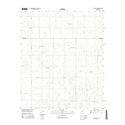
2017 Map of Henshaw Tank
USGS Topo · Published 2017About this map
The arid ranching landscape of Southeast New Mexico is defined by its water-management features and boundary lines in this 2017 survey. Spanning the border between Chaves and Eddy Counties, the terrain is marked by essential livestock watering points such as Henshaw Tank and Bogle Tank. The map reveals a specialized grid of rural transportation, including corridors such as Hagerman Cutoff Rd and Booger Langton Rd, alongside local routes with evocative names like Goat Ropers Rd. This survey documents the modern layout of these high-desert plains, where the vast Public Land Survey System sections, like those in t16s r30e, dictate the placement of roads and resource infrastructure. The area’s character is primarily defined by its utility, supporting regional agriculture and industrial access via routes like E Square Lake Rd.
Find a feature on this map
15 named features on this map. Tap any name to fly to it.
Don’t see what you’re looking for? This feature index may not catch every label — zoom into the map to look around manually.
Map Details
Editions of this 2017 Henshaw Tank Map
This is the sole edition of this map. No revisions or reprints were ever made.
Other maps of this area
1951 · King Camp
USGS Topo · 1:24,000
1953 · Basin Well
USGS Topo · 1:24,000

1954 · Carlsbad
USGS Topo · 1:250,000

1954 · Hobbs
USGS Topo · 1:250,000

1954 · Brownfield
USGS Topo · 1:250,000
1955 · Red Lake SE
USGS Topo · 1:24,000

1955 · Roswell
USGS Topo · 1:250,000

1958 · Carlsbad
USGS Topo · 1:250,000

1958 · Brownfield
USGS Topo · 1:250,000

1958 · Roswell
USGS Topo · 1:250,000