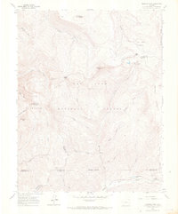
1960 Map of Hermosa Peak
USGS Topo · Published 1967About this map
Graysill Mine and the Spanish King No 1 Mine reflect the extraction history of this corner of the San Juan National Forest, where the high-altitude terrain is defined by the Rico Mountains and Graysyll Mountain. This 1960 field-checked survey highlights a complex network of headwaters including the Dolores River and Hermosa Creek, which originate near the convergence of four county boundaries: Dolores, San Juan, La Plata, and Montezuma.
Find a feature on this map
35 named features on this map. Tap any name to fly to it.
Don’t see what you’re looking for? This feature index may not catch every label — zoom into the map to look around manually.
Map Details
Editions of this 1960 Hermosa Peak Map
4 editions found
Other maps of this area

1897 · Rico
USGS Topo · 1:62,500

1897 · Telluride
USGS Topo · 1:62,500

1898 · Engineer Mountain
USGS Topo · 1:62,500

1898 · Rico
USGS Topo · 1:62,500

1899 · Rico
USGS Topo · 1:62,500

1900 · Engineer Mountain
USGS Topo · 1:62,500

1904 · Telluride
USGS Topo · 1:62,500

1908 · Engineer Mountain
USGS Topo · 1:62,500

1945 · Durango
USGS Topo · 1:250,000

1953 · Mount Wilson
USGS Topo · 1:24,000