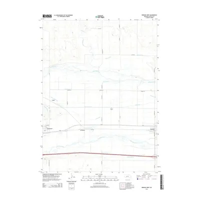
2014 Map of Hershey West
USGS Topo · Published 2014About this map
The North Platte River and South Platte River converge in this section of Lincoln County, defining a landscape shaped by a sophisticated network of irrigation and water management. Small settlements like Sutherland and Hershey anchor the region, connected by the historical corridor of Us-30. The map reveals the critical role of water diversion for the local economy, tracing the paths of the Paxton Hershey Canal, Birdwood Canal, and the Keith-Lincoln Canal as they cut through the Platte Valley. Beyond the main river channels, smaller waterways like Birdwood Creek and Fremont Slough intersect with a grid of rural roads, including Stark Rd and N Sand Rd. Local history and genealogy interests are marked by sites like Riverside Cem, while the rail and road infrastructure at O'Fallons and Coker highlights the area's significance as a transportation throughway in western Nebraska.
Find a feature on this map
38 named features on this map. Tap any name to fly to it.
Don’t see what you’re looking for? This feature index may not catch every label — zoom into the map to look around manually.
Map Details
Editions of this 2014 Hershey West Map
This is the sole edition of this map. No revisions or reprints were ever made.
Other maps of this area

1898 · Paxton
USGS Topo · 1:125,000

1899 · North Platte
USGS Topo · 1:125,000

1901 · Paxton
USGS Topo · 1:125,000

1902 · North Platte
USGS Topo · 1:125,000

1954 · North Platte
USGS Topo · 1:250,000

1956 · North Platte
USGS Topo · 1:250,000

1957 · North Platte
USGS Topo · 1:250,000

1967 · North Platte
USGS Topo · 1:250,000
1970 · North Platte SW
USGS Topo · 1:24,000
1970 · Hershey East
USGS Topo · 1:24,000