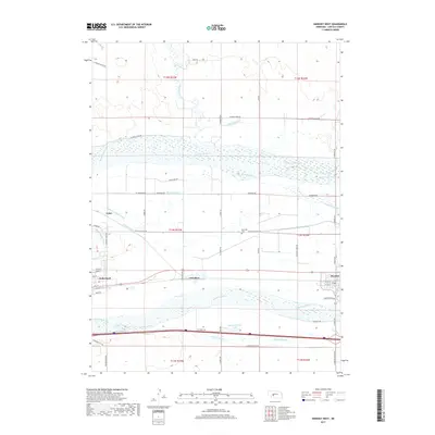
2017 Map of Hershey West
USGS Topo · Published 2017About this map
Sutherland and Hershey anchor this landscape where the twin branches of the Platte River diverge across Lincoln County. The map reveals a complex network of water management essential to the region's agricultural character, featuring the Paxton Hershey Canal, N Platte Canal, and Keith Lincoln Canal cutting through the valley. These irrigation systems parallel the North Platte River and South Platte River, illustrating how the high plains were transformed into productive farmland. Between the rivers, the small settlements of O'Fallons and Coker sit along the transport corridors that follow the natural topography of the river basin.
Find a feature on this map
54 named features on this map. Tap any name to fly to it.
Don’t see what you’re looking for? This feature index may not catch every label — zoom into the map to look around manually.
Map Details
Editions of this 2017 Hershey West Map
This is the sole edition of this map. No revisions or reprints were ever made.
Other maps of this area

1898 · Paxton
USGS Topo · 1:125,000

1899 · North Platte
USGS Topo · 1:125,000

1901 · Paxton
USGS Topo · 1:125,000

1902 · North Platte
USGS Topo · 1:125,000

1954 · North Platte
USGS Topo · 1:250,000

1956 · North Platte
USGS Topo · 1:250,000

1957 · North Platte
USGS Topo · 1:250,000

1967 · North Platte
USGS Topo · 1:250,000
1970 · North Platte SW
USGS Topo · 1:24,000
1970 · Hershey East
USGS Topo · 1:24,000