
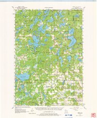
1955 Map of Hertel
USGS Topo · Published 1957About this map
Glacial lakes and wetlands define this portion of Northwest Wisconsin, where the small community of Hertel serves as a central point in the lakeland landscape. Mapping based on 1952 aerial photography reveals a dispersed network of rural infrastructure, from the McKenzie Lake Lookout Tower on the eastern edge to the local Town Hall near Sacred Heart Ch. The distribution of one-room schoolhouses like Moro Sch and Gaslyn Creek Sch suggests a community still largely oriented around localized rural centers before later school consolidations.
Find a feature on this map
98 named features on this map. Tap any name to fly to it.
Don’t see what you’re looking for? This feature index may not catch every label — zoom into the map to look around manually.
Map Details
Editions of this 1955 Hertel Map
2 editions found
Other maps of this area

1947 · Minong
USGS Topo · 1:48,000

1948 · Spooner
USGS Topo · 1:48,000

1949 · Danbury
USGS Topo · 1:48,000

1949 · Hertel
USGS Topo · 1:48,000

1949 · Minong
USGS Topo · 1:48,000

1949 · Webb Lake
USGS Topo · 1:48,000

1949 · Spooner
USGS Topo · 1:48,000

1950 · Webster
USGS Topo · 1:48,000

1951 · Cumberland
USGS Topo · 1:48,000

1951 · Frederic
USGS Topo · 1:48,000