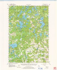
1955 Map of Hertel
USGS Topo · Published 1976About this map
Deep forests and a dense network of glacial lakes define this 1950s landscape across northwestern Wisconsin. The small community of Hertel sits as a central hub, surrounded by dozens of named water bodies like Middle McKenzie Lake and the sweeping Kilkare Marsh. This era of the lake country is characterized by a high density of rural schoolhouses, many serving family farming pockets that have since consolidated. Educational landmarks such as Gaslyn Creek Sch, Scott Sch, and Moro Sch are clearly marked alongside spiritual centers like Sacred Heart Ch and the Evangelical Ch. Local history researchers will find several family-named landmarks and infrastructure of the period, including the McKenzie Lake Lookout Tower and a series of rural cemeteries like Leef Cem and Green Grove Cem. The map illustrates a transitional time in the Northwoods when localized rural institutions were still the primary structure of community life.
Find a feature on this map
102 named features on this map. Tap any name to fly to it.
Don’t see what you’re looking for? This feature index may not catch every label — zoom into the map to look around manually.
Map Details
Editions of this 1955 Hertel Map
2 editions found

Other maps of this area

1947 · Minong
USGS Topo · 1:48,000

1948 · Spooner
USGS Topo · 1:48,000

1949 · Danbury
USGS Topo · 1:48,000

1949 · Hertel
USGS Topo · 1:48,000

1949 · Minong
USGS Topo · 1:48,000

1949 · Webb Lake
USGS Topo · 1:48,000

1949 · Spooner
USGS Topo · 1:48,000

1950 · Webster
USGS Topo · 1:48,000

1951 · Cumberland
USGS Topo · 1:48,000

1951 · Frederic
USGS Topo · 1:48,000