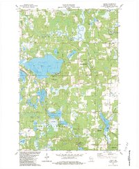
1982 Map of Hertel
USGS Topo · Published 1984About this map
St. Croix Indian Reservation lands anchor this Burnett County landscape, where glacial activity left behind a complex network of wetlands and deep basins. The settlement of Hertel serves as a central point along the east-west corridor, surrounded by significant water bodies such as Big Sand Lake and Pokegama Lake. The local economy of the early 1980s is evidenced by the presence of Cranberry Bogs and the management of conservation areas like the Spring Brook Springs State Fishery Area. To the north, the Yellow River winds through the terrain, crossed by the Whistler Bridge and Pearson Bridge. Local genealogy and community life are marked by the Big Sand Lake Cem and Lakeview Ch, while the southern reaches feature the Clam River and Bashaw Lake, illustrating a region deeply defined by its riparian and lacustrine systems.
Find a feature on this map
53 named features on this map. Tap any name to fly to it.
Don’t see what you’re looking for? This feature index may not catch every label — zoom into the map to look around manually.
Map Details
Editions of this 1982 Hertel Map
2 editions found
Other maps of this area

1949 · Hertel
USGS Topo · 1:48,000

1950 · Webster
USGS Topo · 1:48,000

1951 · Cumberland
USGS Topo · 1:48,000

1951 · Frederic
USGS Topo · 1:48,000

1953 · Stillwater
USGS Topo · 1:250,000

1955 · Hertel
USGS Topo · 1:62,500

1955 · Webster
USGS Topo · 1:62,500

1955 · Frederic
USGS Topo · 1:62,500

1955 · Stillwater
USGS Topo · 1:250,000

1956 · Cumberland
USGS Topo · 1:62,500