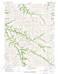
1971 Map of Hessdale
USGS Topo · Published 1974About this map
The Indian Treaty Boundary cuts across the northern landscape of this Wabaunsee County region, a notable historical marker within the drainage basin of Mill Creek. This 1971 survey shows the small settlement of Hessdale positioned near the confluence of East Branch Mill Creek and the main channel. The terrain is defined by a dense network of tributaries including Nehring Creek and Kuenzli Creek, which carve through the townships of Newbury, Farmer, and Mission. Genealogists will find several burial sites preserved on this sheet, such as the Swedish Cem, Troemper Cem, and Nehring Cem, often located on high ground overlooking the creek valleys. These scattered cemeteries and the presence of a local Quarry suggest a decentralized rural economy centered around family homesteads and the natural resources of the Flint Hills region.
Find a feature on this map
19 named features on this map. Tap any name to fly to it.
Don’t see what you’re looking for? This feature index may not catch every label — zoom into the map to look around manually.
Map Details
Editions of this 1971 Hessdale Map
2 editions found
Other maps of this area

1885 · Eskridge
USGS Topo · 1:125,000

1889 · Wamego
USGS Topo · 1:125,000

1889 · Eskridge
USGS Topo · 1:125,000

1894 · Eskridge
USGS Topo · 1:125,000

1894 · Wamego
USGS Topo · 1:125,000

1953 · Maple Hill
USGS Topo · 1:24,000

1954 · Alma
USGS Topo · 1:24,000

1954 · Mc Farland
USGS Topo · 1:24,000

1955 · Manhattan
USGS Topo · 1:250,000

1955 · Hutchinson
USGS Topo · 1:250,000