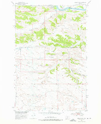
1954 Map of Hessler Ridge
USGS Topo · Published 1976About this map
The Missouri River defines the northern boundary of this landscape, winding past the alluvial flats of McNulty Bottoms, Gardipee Bottoms, and Bell Bottoms. This mid-century survey captures a section of the Fort Peck Game Range in Central Montana, where the terrain rises sharply from the riverbank into a complex system of breaks and coulees. The small settlement of Armells sits near the head of its namesake creek, serving as a rare point of human habitation in a region characterized by dramatic elevation changes. Centered on Hessler Ridge, the map reveals a remote geography of high ridges and deep drainages like Musselman Gulch and Roach Gulch. Land use is primarily dictated by the Range Boundary, illustrating the division between managed wildlife habitat and the high prairie ranching country typical of Fergus County.
Find a feature on this map
23 named features on this map. Tap any name to fly to it.
Don’t see what you’re looking for? This feature index may not catch every label — zoom into the map to look around manually.
Map Details
Editions of this 1954 Hessler Ridge Map
3 editions found
Other maps of this area

1943 · Landusky
USGS Topo · 1:125,000

1954 · Bell Ridge East
USGS Topo · 1:24,000

1954 · Hessler Ridge
USGS Topo · 1:24,000

1954 · Carter Coulee
USGS Topo · 1:24,000

1954 · Bell Ridge West
USGS Topo · 1:24,000

1954 · Grand Island
USGS Topo · 1:24,000

1954 · Lewistown
USGS Topo · 1:250,000

1959 · Lewistown
USGS Topo · 1:250,000

1984 · Zortman
USGS Topo · 1:100,000

1985 · Griffee Coulee
USGS Topo · 1:24,000