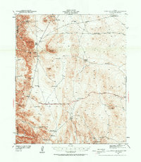
1941 Map of Heuco Mountains
USGS Topo · Published 1958About this map
Helm Cem and the Helms Ranch sit at the western edge of the high desert terrain as it was recorded just before the United States entered World War II. This landscape is defined by its reliance on dispersed water catchments, with numerous tanks such as Last Chance Tank, Antelope Tanks, and Panther Tanks supporting life and transit across the arid flats. The map documents the overlap of traditional and modern transportation routes, showing the Butterfield Trail and Old Butterfield Road cutting through the northern reaches, while the Carlsbad Highway provides a more direct southern passage. Prominent peaks including Cerro Alto Mtn and Naville Mtn rise above the Lake Bed, creating a topographical record of the northern Hueco Mountains that is essential for understanding the early 20th-century ranching and transit infrastructure of this border region.
Find a feature on this map
42 named features on this map. Tap any name to fly to it.
Don’t see what you’re looking for? This feature index may not catch every label — zoom into the map to look around manually.
Map Details
Editions of this 1941 Heuco Mountains Map
2 editions found
Other maps of this area

1896 · El Paso
USGS Topo · 1:125,000

1903 · Cerro Alto
USGS Topo · 1:125,000

1908 · El Paso
USGS Topo · 1:125,000

1939 · Heuco Tanks
USGS Topo · 1:62,500

1940 · Heuco Tanks
USGS Topo · 1:62,500

1940 · Bassett Lake
USGS Topo · 1:62,500

1941 · Clint
USGS Topo · 1:62,500

1941 · Heuco Mountains
USGS Topo · 1:62,500

1941 · Desert
USGS Topo · 1:62,500

1942 · Borrego
USGS Topo · 1:62,500