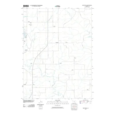
2010 Map of Hiattsville
USGS Topo · Published 2010About this map
Chariton River meanders across this rural landscape in Appanoose County, south of the massive Rathbun Dam. The area is characterized by a dense network of country roads and scattered historic settlements, including Maine, Hiattsville, and Darbyville. Genealogists will find a wealth of burial records across this sheet, which identifies numerous family and community sites such as Fairview Cemetery, Haynes Cemetery, and Perjue Cemetery. The presence of the Rathbun Fish Hatchery and Rathbun Lake Airport reflects the region's development around the reservoir infrastructure. North of the river, smaller waterways like Snyder Branch and Snort Creek feed into the larger system, while Lake Sundown occupies the northeastern corner of the quadrangle.
Find a feature on this map
65 named features on this map. Tap any name to fly to it.
Don’t see what you’re looking for? This feature index may not catch every label — zoom into the map to look around manually.
Map Details
Editions of this 2010 Hiattsville Map
This is the sole edition of this map. No revisions or reprints were ever made.
Other maps of this area

1939 · Centerville
USGS Topo · 1:62,500

1939 · Mystic
USGS Topo · 1:62,500

1941 · Centerville
USGS Topo · 1:62,500

1942 · Mystic
USGS Topo · 1:62,500

1954 · Centerville
USGS Topo · 1:250,000

1957 · Centerville
USGS Topo · 1:250,000

1958 · Centerville
USGS Topo · 1:250,000

1966 · Hiattsville
USGS Topo · 1:24,000
1966 · Mystic
USGS Topo · 1:24,000

1968 · Unionville
USGS Topo · 1:24,000