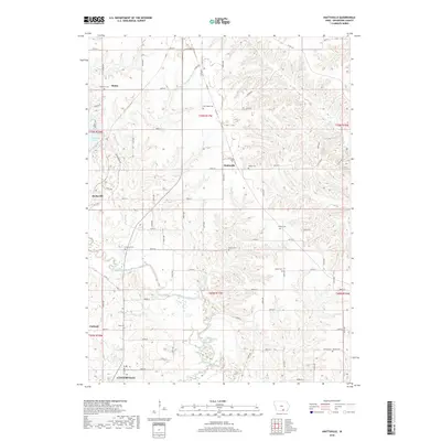
2018 Map of Hiattsville
USGS Topo · Published 2018About this map
The Chariton River meanders across this rural Iowa landscape, defining the topography of north-central Appanoose County. Small unincorporated communities like Hiattsville, Darbyville, and Maine anchor the surrounding townships, providing a look at the settlement patterns that persist into the 21st century. The map is particularly dense with burial sites that are invaluable for genealogical research, including New Hope Cem, Denny Cem, and Haynes Cem. In the south, the northern edge of Centerville appears, showing the transition from agricultural land to more developed residential corridors. The western edge of the quadrangle is marked by the shoreline of Rathbun Lake, a significant water feature that shapes local drainage. From the ridges of Boyer Ridge Rd to the valleys of Snyder Br and S Soap Cr, the map illustrates a complex network of county roads and creek systems that have supported local farming for generations.
Find a feature on this map
80 named features on this map. Tap any name to fly to it.
Don’t see what you’re looking for? This feature index may not catch every label — zoom into the map to look around manually.
Map Details
Editions of this 2018 Hiattsville Map
This is the sole edition of this map. No revisions or reprints were ever made.
Other maps of this area

1939 · Centerville
USGS Topo · 1:62,500

1939 · Mystic
USGS Topo · 1:62,500

1941 · Centerville
USGS Topo · 1:62,500

1942 · Mystic
USGS Topo · 1:62,500

1954 · Centerville
USGS Topo · 1:250,000

1957 · Centerville
USGS Topo · 1:250,000

1958 · Centerville
USGS Topo · 1:250,000

1966 · Hiattsville
USGS Topo · 1:24,000
1966 · Mystic
USGS Topo · 1:24,000

1968 · Unionville
USGS Topo · 1:24,000