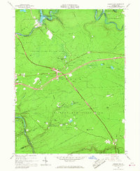
1966 Map of Hickory Run
USGS Topo · Published 1967About this map
Hickory Run State Park dominates this mid-1960s landscape, illustrating a transition from industrial exploitation to a massive public recreational resource. The Lehigh River carves a deep path through the terrain, its flow regulated by the Francis E Walter Reservoir at the northern boundary. While the river corridor still shows the footprint of the Central Railroad of New Jersey, the newer infrastructure of the Pennsylvania Turnpike Northeast Extension and Interstate 80 signifies the era's shift toward high-speed automobile travel. Settlement remains sparse, represented by small clusters like Leonardsville and Saylorsville, alongside the early development of Pocono Mountain Lake Estates. Natural curiosities are also prominent, most notably the Boulder Field on the slopes of Chestnut Ridge, providing a detailed look at the region’s unique periglacial features.
Find a feature on this map
58 named features on this map. Tap any name to fly to it.
Don’t see what you’re looking for? This feature index may not catch every label — zoom into the map to look around manually.
Map Details
Editions of this 1966 Hickory Run Map
Other maps of this area

1889 · Hazleton
USGS Topo · 1:62,500

1891 · Wilkesbarre
USGS Topo · 1:62,500

1891 · Hazleton
USGS Topo · 1:62,500

1893 · Hazleton
USGS Topo · 1:62,500

1894 · Wilkesbarre
USGS Topo · 1:62,500

1922 · Mauch Chunk
USGS Topo · 1:62,500

1922 · Stoddartsville
USGS Topo · 1:62,500

1924 · Stoddartsville
USGS Topo · 1:62,500

1924 · Mauch Chunk
USGS Topo · 1:62,500

1943 · Scranton
USGS Topo · 1:125,000
Featured Places
- Kidder Township, PA
- Buck Township, PA
- Penn Forest Township, PA
- Tobyhanna Township, PA
- Saylorsville, Kidder Township