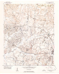
1951 Map of Hickory Valley
USGS Topo · Published 1980About this map
Hickory Valley and the surrounding West Tennessee landscape appear here just after the mid-century, defined by a dense network of rural schoolhouses and neighborhood churches. The Illinois Central railroad cuts through the eastern portion of the sheet, anchoring the local economy and connecting small communities like Newcastle. The terrain is deeply etched by the North Fork Wolf River and its many tributaries, including Mc Kinnie Creek and May Creek, which dictate the placement of early homesteads and roads. For those tracing family histories in Hardeman and Fayette counties, the map serves as a detailed record of local gathering places such as Morrow Hill Sch, May Hill Sch, and Jopic Sch. Significant cemetery sites like Mt Comfort Cem and Woods Cem are clearly marked, providing essential landmarks for genealogical research in this agrarian region.
Find a feature on this map
23 named features on this map. Tap any name to fly to it.
Don’t see what you’re looking for? This feature index may not catch every label — zoom into the map to look around manually.
Map Details
Editions of this 1951 Hickory Valley Map
3 editions found
Other maps of this area

1949 · Moscow
USGS Topo · 1:62,500

1950 · Middleburg
USGS Topo · 1:24,000

1950 · Grand Junction
USGS Topo · 1:24,000

1951 · Middleburg
USGS Topo · 1:24,000

1951 · Hickory Valley
USGS Topo · 1:24,000

1951 · Grand Junction
USGS Topo · 1:24,000

1952 · Saulsbury
USGS Topo · 1:24,000

1952 · Laconia
USGS Topo · 1:24,000

1952 · Stanton
USGS Topo · 1:62,500

1956 · Blytheville
USGS Topo · 1:250,000