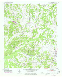
1951 Map of Hickory Valley
USGS Topo · Published 1981About this map
Hickory Valley and its surrounding countryside are documented in this mid-century survey, revealing a landscape defined by small rural centers and numerous community institutions. The settlement pattern is characterized by its network of schools and churches, such as Morrow Hill Sch, Polk Sch, and Mt Comfort Ch, which served the local population across the Fayette and Hardeman County line. Transport and drainage are closely linked here, with the Illinois Central and Gulf Mobile and Ohio railroads traversing the region near the North Fork Wolf River.
Find a feature on this map
25 named features on this map. Tap any name to fly to it.
Don’t see what you’re looking for? This feature index may not catch every label — zoom into the map to look around manually.
Map Details
Editions of this 1951 Hickory Valley Map
3 editions found
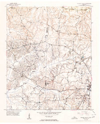
Other maps of this area

1949 · Moscow
USGS Topo · 1:62,500

1950 · Middleburg
USGS Topo · 1:24,000

1950 · Grand Junction
USGS Topo · 1:24,000

1951 · Middleburg
USGS Topo · 1:24,000

1951 · Hickory Valley
USGS Topo · 1:24,000

1951 · Grand Junction
USGS Topo · 1:24,000

1952 · Saulsbury
USGS Topo · 1:24,000

1952 · Laconia
USGS Topo · 1:24,000

1952 · Stanton
USGS Topo · 1:62,500

1956 · Blytheville
USGS Topo · 1:250,000