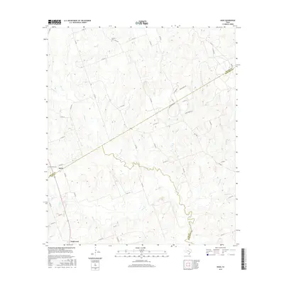
2016 Map of Hicks
USGS Topo · Published 2016About this map
Hicks and Tanglewood anchor this 2016 survey of the rolling borderlands between Lee, Milam, and Burleson counties. The landscape is defined by the winding course of E Yegua Cr, which serves as a natural boundary while drawing in a network of tributaries including Allen Cr, Reece Cr, and Hills Br. This modern topographical record shows a region of low-density rural settlement, where traditional local-history markers like Harmony Cem and Forest Grove Cem persist alongside evidence of regional energy infrastructure. The presence of Oil Field Rd and several private roads suggests the ongoing importance of resource extraction and large-tract land use in this part of Texas. A dense web of county roads, such as Co RD 412 and Co RD 314, provides clear documentation of the contemporary transportation grid connecting these small communities.
Find a feature on this map
50 named features on this map. Tap any name to fly to it.
Don’t see what you’re looking for? This feature index may not catch every label — zoom into the map to look around manually.
Map Details
Editions of this 2016 Hicks Map
This is the sole edition of this map. No revisions or reprints were ever made.
Other maps of this area
1885 · Taylor
USGS Topo · 1:125,000
1885 · Bastrop
USGS Topo · 1:125,000
1887 · Taylor
USGS Topo · 1:125,000
1893 · Bastrop
USGS Topo · 1:125,000
1894 · Taylor
USGS Topo · 1:125,000
1904 · Bastrop
USGS Topo · 1:125,000
1919 · Dime Box
USGS Topo · 1:62,500
1948 · Lexington
USGS Topo · 1:62,500
1950 · Lexington
USGS Topo · 1:62,500

1954 · Austin
USGS Topo · 1:250,000