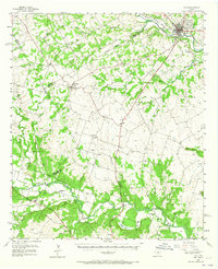
1956 Map of Hico
USGS Topo · Published 1965About this map
The Bosque River and Leon River systems anchor this mid-century survey of Hamilton and Erath Counties, where the landscape transitions from established agricultural hubs to smaller rural outposts. Hico serves as the primary municipal center in the northeast, while the smaller settlement of Carlton sits at the intersection of several county roads to the west. A notable feature of the local infrastructure is the Old Railroad Grade running parallel to the Leon River near the site of Springtown, suggesting the shift from rail-based transport to regional highways like the American Legion Memorial Highway. Genealogists will find a high density of small family or community burial grounds, including Tillinghouse Cem, Preacher Cem, and Honey Creek Cem, which often represent the only remaining markers of vanished early-Texas settlements like Sunshine and Spurlin.
Find a feature on this map
54 named features on this map. Tap any name to fly to it.
Don’t see what you’re looking for? This feature index may not catch every label — zoom into the map to look around manually.
Map Details
Editions of this 1956 Hico Map
2 editions found

Other maps of this area

1888 · Hamilton
USGS Topo · 1:125,000

1888 · Meridian
USGS Topo · 1:125,000

1889 · Granbury
USGS Topo · 1:125,000

1890 · Stephenville
USGS Topo · 1:125,000

1894 · Hamilton
USGS Topo · 1:125,000

1894 · Meridian
USGS Topo · 1:125,000

1920 · Stephenville
USGS Topo · 1:125,000

1954 · Brownwood
USGS Topo · 1:250,000

1954 · Dallas
USGS Topo · 1:250,000

1954 · Waco
USGS Topo · 1:250,000