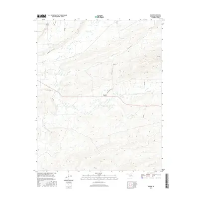
2016 Map of Higgins
USGS Topo · Published 2016About this map
Higgins serves as the central hub of this topographical study in the heart of the Ouachita foothills, where rural life is defined by the winding paths of Gaines Creek and its many tributaries. The settlement is positioned along the Higgins Damon Valley Rd, connecting local homesteads to the rugged heights of Number Ten Mtn and Blue Mtn. For those investigating local genealogy, the Mountain Station Cem and the access provided by Gowen Cemetary Rd offer significant points of interest. The landscape is characterized by a complex drainage system, including Buffalo Cr and Pine Cr, which cut through the varied elevations. The map provides a detailed view of the modern road network, such as Mountain Station Rd and Snake Rd, illustrating how the community persists within this transition between the valley floor and the surrounding mountain ridges.
Find a feature on this map
24 named features on this map. Tap any name to fly to it.
Don’t see what you’re looking for? This feature index may not catch every label — zoom into the map to look around manually.
Map Details
Editions of this 2016 Higgins Map
This is the sole edition of this map. No revisions or reprints were ever made.
Other maps of this area
1898 · McAlester
USGS Topo · 1:125,000
1901 · Tuskahoma
USGS Topo · 1:125,000
1908 · Tuskahoma
USGS Topo · 1:125,000
1909 · Mc Alester
USGS Topo · 1:125,000
1909 · Tuskahoma
USGS Topo · 1:125,000
1950 · Mcalester
USGS Topo · 1:250,000
1962 · McAlester
USGS Topo · 1:250,000
1965 · McAlester
USGS Topo · 1:250,000
1967 · Adamson
USGS Topo · 1:24,000
1967 · Hartshorne
USGS Topo · 1:24,000